 Dataregister Rijkswaterstaat
Orthofotomozaiek Oosterschelde 2021
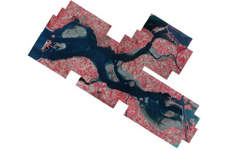
Orthofotomozaiek van het projectgebied Westerschelde vervaardigd uit stereoluchtfoto-opnamen op 22-09-2021 ter ondersteuning van het vegetatie monitoringsprogramma in opdracht van WVL
Standard
Basis
- Date (Creation)
- 2021-09-22
- Unique resource identifier
- f2d50179-1fab-4d20-a53d-6ee94gd2281g
- Status
- Completed
- Metadata language
- Nederlands; Vlaams
- Keywords
-
- Luchtfoto
- geomorfologie
- MWTL
- N2000
- platen
- slikken
- schorren
- kwelders
- intergetijdegebied
- ecotopen
- hydrodynamiek
- KRW
- Natuur en Milieu
- biologische monitoring
- Use limitation
- Geen beperkingen
Legal constraints
- Use limitation
- Geen beperkingen
- Access constraints
- Other restrictions
- Use constraints
- Other restrictions
- Other constraints
- Geen beperkingen
Security constraints
- Classification
- Unclassified
Owner
Rijkswaterstaat
-
Servicedesk Data
(
Verstrekker
)
Derde Werelddreef 1
,
Delft
,
Zuid-Holland
,
3000 AN
,
Nederland
https://www.rijkswaterstaatdata.nl/
))
DataQuality
- Hierarchy level
- Dataset
- Lineage
- Product is vervaardigd volgens specificaties dienst luchtfoto´s en orthofotomozaieken versie 2.13 maart 2021 van de CIV
Metadata
- Metadata language
- Nederlands; Vlaams
- Hierarchy level
- Dataset
Point of contact
Rijkswaterstaat
-
Servicedesk Data
(
Contactpunt
)
Derde Werelddreef 1
,
Delft
,
Zuid-Holland
,
3000 AN
,
Nederland
https://www.rijkswaterstaatdata.nl/